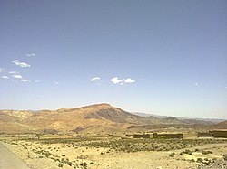
Datakhel
Datakhel
دته خېل | |
|---|---|
Town | |
 | |
| Coordinates: 32°54′18.4″N 69°44′56″E / 32.905111°N 69.74889°E | |
| Country | |
| Province | |
| District | North Waziristan |
| Tehsil | Datta Khel |
| Elevation | 2,010 m (6,590 ft) |
| Population | |
| • Total | 1,037 |
| Time zone | UTC+5 (PST) |
Datakhel (Pashto: دته خېل) or Datta Khel is a town in North Waziristan district of Khyber Pakhtunkhwa, Pakistan.[2][3][4]
It is part of Datta Khel Tehsil of North Waziristan district.[5]
Overview and history[edit]
Datakhel is located around 41 km South West of near by towns of Miran Shan and 21 km of Boya in North Wizaristan.[6][7][8] According to the 2017 census, the population of Datakhel, is 1037 with total number of household stands at 171.[1]
On Sept 25, 2008, as an indication of escalating tensions between nations, Pakistani forces fired warning shots at American aircraft after they crossed into Pakistan's territory in the area of Saidgai, in North Waziristan's Datakhel region.
On March 17, 2011, a US airstrike that killed 44 people in the city led to widespread condemnation in Pakistan.[9]
See also[edit]
References[edit]
- ^ a b "POPULATION AND HOUSEHOLD DETAIL FROM BLOCK TO DISTRICT LEVEL: FATA (NORTH WAZIRISTAN)" (PDF). www.pbscensus.gov.pk. 2018-01-03. Archived from the original (PDF) on 2018-04-03. Retrieved 2018-04-02.
- ^ "President signs amendment bill, merging FATA with KP". Geo News. Archived from the original on 2018-06-15. Retrieved 2018-06-26.
- ^ Dawn.com, Amir Wasim (2018-05-24). "National Assembly green-lights Fata-KP merger by passing 'historic' bill". DAWN.COM. Archived from the original on 2018-06-18. Retrieved 2018-06-26.
- ^ Farooq, Umar (2017-12-06). "In Pakistan's Tribal Areas, Collective Punishment Is the Law of the Land". The Nation. ISSN 0027-8378. Archived from the original on 2018-06-26. Retrieved 2018-06-26.
- ^ "DISTRICT AND TEHSIL LEVEL POPULATION SUMMARY WITH REGION BREAKUP - North Waziristan" (PDF). www.pbscensus.gov.pk. Archived from the original (PDF) on 2018-06-27. Retrieved 2018-06-26.
- ^ Frontier Works Organization, Pakistan. "Miranshah - Boya - Datta Khel Roads". www.fwo.com.pk. Archived from the original on 2018-06-27. Retrieved 2018-06-27.
- ^ Col. H. C. Wylly (2011). History of the 5th Battalion 13th Frontier Force Rifles: 1849–1926. Andrews UK Limited, 2011. p. 60. ISBN 9781781493311.
- ^ Michael Lowry (2009). Fighting Through to Kohima: A Memoir of War in India and Burma. Casemate Publishers. p. 53. ISBN 9781844158027.
- ^ "80 people reportedly killed in US drone strike in Pakistan". Xinhua. 17 March 2011. Archived from the original on 18 March 2011. Retrieved 17 March 2011.
