
File:Atomic bomb 1945 mission map.svg

Size of this PNG preview of this SVG file: 456 × 600 pixels. Other resolutions: 182 × 240 pixels | 365 × 480 pixels | 584 × 768 pixels | 778 × 1,024 pixels | 1,556 × 2,048 pixels | 1,919 × 2,525 pixels.
Original file (SVG file, nominally 1,919 × 2,525 pixels, file size: 392 KB)
| This is a file from the Wikimedia Commons. Information from its description page there is shown below. Commons is a freely licensed media file repository. You can help. |
Summary
| Description |
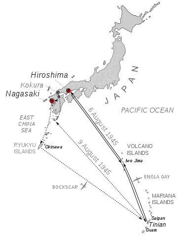
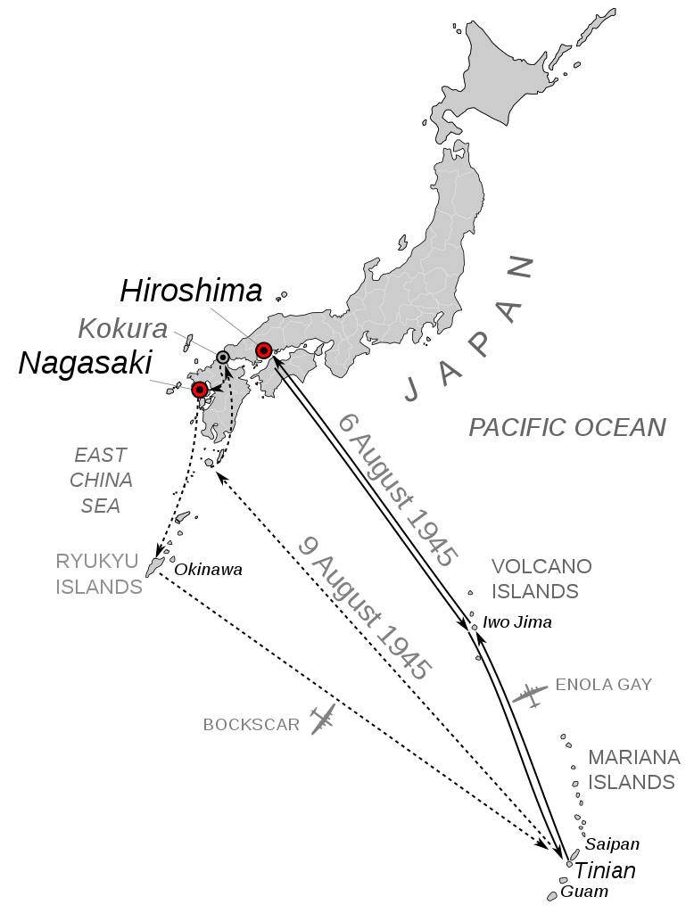
English: Mission map for the bombings of Hiroshima and Nagasaki, August 6 and August 9, 1945. Scale is not consistent due to curvature of Earth. Angles and locations are approximate. Kokura included because it was original target for August 9 but weather obscured visibility and so Nagasaki was chosen as backup.
Deutsch: Einsatzkarte für die Bombenangriffe auf Hiroshima und Nagasaki am 6. und 9. August 1945. Der Maßstab ist aufgrund der Erdkrümmung nicht einheitlich. Winkel und Standorte sind ungefähre Angaben. Kokura wurde mit einbezogen, weil es das ursprüngliche Ziel für den 9. August war, aber das Wetter die Sicht behinderte, so dass Nagasaki als Ersatzziel gewählt wurde. |
| Date | |
| Source | Own work, Based on File:Japan_large_full.svg and this Department of Energy map. archive copy at the Wayback Machine |
| Author | Mr.98 |
| Other versions |
|
| Software | This W3C-unspecified vector image was created with Inkscape . |


Licensing
| I, the copyright holder of this work, release this work into the public domain. This applies worldwide. In some countries this may not be legally possible; if so: I grant anyone the right to use this work for any purpose, without any conditions, unless such conditions are required by law. |
File history
Click on a date/time to view the file as it appeared at that time.
| Date/Time | Thumbnail | Dimensions | User | Comment | |
|---|---|---|---|---|---|
| current | 22:17, 9 August 2010 | | 1,919 × 2,525 (392 KB) | Mr.98 | |
| 22:15, 9 August 2010 |  | 1,919 × 2,525 (392 KB) | Mr.98 | ||
| 13:31, 9 August 2010 |  | 1,919 × 2,525 (385 KB) | Mr.98 | ||
| 13:27, 9 August 2010 |  | 1,919 × 2,525 (385 KB) | Mr.98 | ||
| 13:26, 9 August 2010 |  | 1,842 × 2,525 (383 KB) | Mr.98 | ||
| 13:25, 9 August 2010 |  | 1,842 × 2,525 (383 KB) | Mr.98 | ||
| 13:17, 9 August 2010 |  | 1,842 × 2,525 (381 KB) | Mr.98 | {{Information |Description={{en|1=Mission map for the bombings of Hiroshima and Nagasaki, August 6 and August 9, 1945. Scale is not consistent due to curvature of Earth. Angles and locations are approximate. Kokura included because it was original target |
File usage
The following pages on the English Wikipedia use this file (pages on other projects are not listed):
Global file usage
The following other wikis use this file:
- Usage on bg.wikipedia.org
- Usage on cs.wikipedia.org
- Usage on de.wikipedia.org
- Usage on eo.wikipedia.org
- Usage on es.wikipedia.org
- Usage on et.wikipedia.org
- Usage on fr.wikipedia.org
- Usage on hu.wikipedia.org
- Usage on id.wikipedia.org
- Usage on ja-two.iwiki.icu
- Usage on ko.wikipedia.org
- Usage on mk.wikipedia.org
- Usage on pl.wikipedia.org
- Usage on pt.wikipedia.org
- Usage on sv.wikipedia.org
- Usage on te.wikipedia.org