
Glen Davis, New South Wales
| Glen Davis New South Wales | |||||||||||||||
|---|---|---|---|---|---|---|---|---|---|---|---|---|---|---|---|
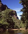
Glen_Davis.jpg) Countryside around Glen Davis | |||||||||||||||
 Glen Davis | |||||||||||||||
 | |||||||||||||||
| Coordinates | 33°07′26″S 150°16′54″E / 33.12389°S 150.28167°E | ||||||||||||||
| Population | 115 (2016 census)[1] | ||||||||||||||
| Postcode(s) | 2846[2] | ||||||||||||||
| Elevation | 290 m (951 ft)[3] | ||||||||||||||
| Location | |||||||||||||||
| LGA(s) | City of Lithgow | ||||||||||||||
| State electorate(s) | Bathurst | ||||||||||||||
| Federal division(s) | Calare | ||||||||||||||
| |||||||||||||||
Glen Davis is a village in the Central Tablelands of New South Wales, Australia. The village is located in the local government area of the City of Lithgow. It is located 250 km north-west of Sydney and approximately 80 kilometres north of Lithgow.[4] The name is also applied to the surrounding area, for postal and statistical purposes. In the 2006 census, Glen Davis had a population of 354[1] but this fell to 115 in the 2016 census.[5]
Location[edit]
Glen Davis is situated in the Capertee Valley, from which the Capertee River flows.[6][7] Glen Davis is located north of Lithgow, New South Wales, off the road to Mudgee. It lies just to the east of the Great Dividing Range, as the Capertee River is part of the Hawkesbury-Nepean river system. The nearest other town is Capertee, which formerly had the closest connection to Glen Davis by rail.
Its location was due originally to the presence of deposits of oil shale and coal nearby. Disadvantages of Glen Davis's location were its relative remoteness, its relatively low rainfall, and, paradoxically, that the lower part of its site is subject to flooding during heavy rains.[8][9][10]
History[edit]
Before Glen Davis[edit]
Aboriginal and early settler history[edit]
The Wiradjuri people are the original inhabitants of the Capertee Valley[11][12] and the location now known as Glen Davis. The valley is in the north-eastern corner of the traditional lands of the Wiradjiri, near the boundary with the Darkinyung lands.[13]
European settlers colonised and took over land in the valley, beginning in the 1820s, and progressively cleared the land on the valley floor for grazing and European agriculture.
Early mining and North Newnes[edit]
In 1865, oil shale was found in the Capertee Valley, on both the northern and southern sides. It was first mined there in 1881, including from a adit in the southern side of the valley, known as 'MP1', which would many years later be the site of the Glen Davis shale mine.[14]
During the early 20th-Century, a small settlement known as North Newnes existed in the Capertee Valley close to the portal of a tunnel that was being driven to connect the valley with the oil shale operations in the Wolgan Valley at Newnes (then also known as South Newnes).[15][16] The two settlements were connected by a bridle track between the two valleys.[17] The tunnel, known as 'Lang's Tunnel'—begun first in the 1890s—lay west of the later oil shale mine; it had a length of 4,300 ft (1,300 m),[18] by the time that work on it was abandoned in September 1906.[19] The miners had left the site by November 1908.[20] The site of North Newnes was probably on higher ground above the future site Glen Davis township.[18] Shale mining took place in the valley as late as 1923.[14]
None of these early ventures produced significant amounts of shale, as getting the shale out of the remote valley for processing was not economic.
Shale oil town (1938–1952)[edit]
From 1938, the area adjacent to the site of Glen Davis became the centre of a revival of the oil shale industry. The town was established under an Act of the N.S.W. Parliament in December 1939.[21] It was named after George Francis Davis.[22] Glen Davis was notable because it was the first time that there had been an attempt in N.S.W. to create a completely new town based on town planning principles.[23][24]
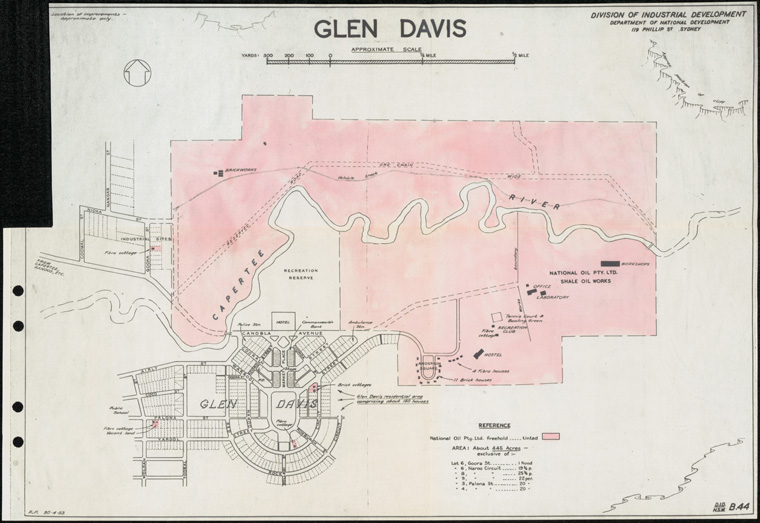
Construction of the Glen Davis Oil Shale Works began in 1938, before the town existed,[25] and the earliest workers had to live in tents or otherwise make their own housing. This shanty housing often made use of white-washed hessian bagging and other inexpensive materials that were to hand,[26] and the area became known at the 'Bag Town'. It was not within the neat planned township but on the opposite side of the Capertee River, on river flats prone to flooding.[27][28] The settlement known as 'Glen Davis' thus came to consist of the planned town of Glen Davis, on the southern side of the river, the 'Bag Town' on the northern side, and a little to the east—between the town centre and the works, on land owned by National Oil Proprietary Limited—an area of staff and employee housing. There was also a planned industrial area to the north-west of the town centre.[29]
The Glen Davis Oil Shale Works first made shale oil in January 1940.[30] The post office for the town opened on 1 March 1939.[31] The school opened in January 1940.[32] Land sales in the town occurred in March 1940 but none of the residential sites were sold at the time.[33] Conditions of sale for residential blocks were relaxed later in 1940.[34] Houses later built there were financed and constructed under a cooperative building scheme, under which no deposit was required but equity was allocated based on the value of rental payments made.[35][36]
In 1947, Glen Davis had a population of approximately 1,600, who were accommodated as follows: 11 substantial brick houses for staff; a staff hostel made of brick accommodating 30 junior staff; 100 permanent and 50 'war-type' individually-owned residences; a group of barracks with accommodation and boarding for 300 single men; a commercial hotel with 25 rooms; and a 'Bag Town' of 250 mostly sub-standard dwellings. The school had 260 pupils and 7 teachers. There was a post office, a bank and a police station. The town had a doctor, a pharmacist, three churches, a community centre, golf course, bowling green, children's playground and tennis courts. There were few commercial outlets; two general stores; a pharmacy; a garage; a 'saloon' (a bar separate from the hotel); a barber shop; and the hotel. There was also a motion-picture theatre in the 'Bag Town' section.[35]
Driven by government policy and a shortage of labour for the shale oil operations, post-war migrants settled in the town from around 1948, facing hostility from some workers and residents.[37][38]
At its peak, the population reached approximately 2000. There was an ambulance station, with two ambulances, that had been funded by the people of the town.[39] There was also a bakery.[40] From 1949, the town had a reticulated water supply. The water was piped over 105 km from the Oberon Dam on the Fish River,[41] a rare instance of water from the Murray-Darling catchment being supplied to a location that is east of the Great Dividing Range.
Decline[edit]
The works and the associated shale and coal mines were closed and abandoned, in May 1952, because the works was unprofitable and accumulated losses were approaching the value of the capital and advances involved.[42] By late 1952, there were 50 vacant houses in the town.[43] Home owners received some compensation from the Commonwealth Government.[44][45] Equipment in the plant was auctioned off in early 1953, by which time the ambulance station had closed, the town was taking on a forlorn unkempt appearance, and the population had fallen to 460.[46] There was some work available in dismantling parts of the shale oil works during 1953. By mid-1954, the population had fallen to 320, there were 80 empty houses, only three shops were left open— general merchant, butcher and newsagent— and the town had lost its doctor, police station and clergymen. What was left uninhabited was subject to damage by vandals and thieves from outside the town [47] The population had dwindled to 195, by late 1954.[40] The skeleton of a town survived in the form of some properties, a hotel, a post office, and a shop or two that operated intermittently. Many houses and other building in the town were either relocated or demolished; some others just decayed away over time. The school closed in February 1962.[32] The post office closed on 1 October 1986.[31]
Present day Glen Davis[edit]
The creation of the Wollemi National Park brought a degree of tourism to the area and the ruins of the oil shale works are now also a minor tourist attraction. Some buildings associated with the old town are now used for tourist accommodation, including the hotel, in the old township,[48] and the former Inspector's and General Manager's cottages, at the locality known as 'the Poplars'[49] that lies between the modern-day village and the ruins of the works. The parkland reserve, at the centre of the old town plan, is now the Glen Davis Campground.[50] A lasting legacy of the shale oil era is that the village still receives its freshwater supply via the concrete pipeline from the Oberon Dam.[51]
National Parks[edit]
The Wollemi National Park takes in 492,976 hectares and is the second-largest national park in New South Wales. It includes some parts of the Capertee Valley, especially downstream of Glen Davis.[52] The National Parks and Wildlife Service marked out a track between Glen Davis and Newnes, in the Wolgan Valley, and this became a popular walk known as the Pipeline Pass.[53][54] Bushwalkers also use Glen Davis as the starting point for camping trips in the national park; there is also a camp site in the town.
Nearby are two smaller parks, the Mugii Murum-ban State Conservation Area[55] — an area of particular significance to Wiradjuri people — and the Capertee National Park.[56]
Another national park was created later, known as the Gardens of Stone National Park. This takes in some areas around the Capertee Valley, including the flat-topped mountain—or butte—called Pantony's Crown. This mountain was named after an early farmer who opened the area up to sheep farming.[57] The National Trail, a long-distance walking trail that goes from Melbourne to Cooktown, also passes through the Capertee Valley.
Popular culture[edit]
The town was the subject of a documentary film, No Such Place, which was the first film made by the Australian director Peter Butt, in 1981.[58]
The Glen Davis Shale Oil Works and a property now resumed into the National Park downstream from these sites was the location (Paradise Valley) for the 1980 Australian movie The Chain Reaction. The movie was directed by Ian Barry and starred Mel Gibson (uncredited)[59] Steve Bisley, Hugh Keays-Byrne, Roger Ward and Tim Burns, amongst other fellow Mad Max cast and crew. Cinematography by Russell Boyd, and had George Miller as First Assistant Director.[60] Many locals appeared in the movie as extras.
Gallery[edit]
-
 Part of Glen Davis, with a backdrop of the Wollemi National Park. The hotel is at the centre of the photograph.
 -
 Abandoned shops in Market Place, Glen Davis (Jan. 2005)
 -
 Ruins of Glen Davis Shale Oil Works.
 -
 Capertee River downstream of Glen Davis
 -
 Pantonys Crown, west of Glen Davis
 -
 Mount Gundangaroo seen from Glen Davis
 -
 Farmland, Glen Davis
 -
![Town Plan of Glen Davis (1939)[24]](//upload.wikimedia.org/wikipedia/commons/thumb/7/77/Glen_Davis_Town_Plan_by_A.A.Cooke_%28Lithgow_Mercury_Fri_1_Dec_1939%2C_Page_5%29.jpg/120px-Glen_Davis_Town_Plan_by_A.A.Cooke_%28Lithgow_Mercury_Fri_1_Dec_1939%2C_Page_5%29.jpg) Town Plan of Glen Davis (1939)[24]
Town Plan of Glen Davis (1939)[24] -
 Postmark of the former post office at Glen Davis, made on the day that it closed, 1 October 1986.
 -
 Workers' camp c. 1940 before there was sufficient housing in the new town of Glen Davis.
Glen_Davis-2.jpg)


Capertee_River-1.jpg)
Pantonys_Crown_Capertee_Valley.jpg)
Glen_Davis_view_Mt_Gundangaroo.jpg)
Glen_Davis_morning_mist-1.jpg)
![Town Plan of Glen Davis (1939)[24]](/wiki/File:Glen_Davis_Town_Plan_by_A.A.Cooke_(Lithgow_Mercury_Fri_1_Dec_1939,_Page_5).jpg)

.jpg)
See also[edit]
- Glen Davis Shale Oil Works
- List of Blue Mountains articles
- Newnes
- Wolgan Valley
- Wollemi National Park
- Capertee, New South Wales
- George Francis Davis
References[edit]
- ^ a b Australian Bureau of Statistics (25 October 2007). "2006 Census QuickStats: Glen Davis". 2006 Census QuickStats. Retrieved 5 July 2008.
- ^ Glen Davis Postcode Australia Post
- ^ "Daily rainfall - Glen Davis Post Office". Climate Data Online. Bureau of Meteorology. Retrieved 19 November 2011.
- ^ Robinson's Road Atlas of Australia, Edition 8 (Lansdowne Press) 1983, Map 204
- ^ "2016 Census QuickStats: Glen Davis". quickstats.censusdata.abs.gov.au. Retrieved 6 July 2020.
- ^ "Capertee Valley". Lithgow Visitor Information Centre. Archived from the original on 13 July 2011.
- ^ "Dr Karl". Australian Broadcasting Corporation. 22 May 2012. Retrieved 26 April 2014.
- ^ "Glen Davis Getting Back To Normal". Lithgow Mercury (NSW: 1898–1954). 18 December 1947. p. 2. Retrieved 5 July 2020.
- ^ "LivesLost, People Marooned As NSW Deluge Goes On". Daily News (Perth, WA: 1882–1950). 18 June 1949. p. 1. Retrieved 30 June 2020.
- ^ "Glen Davis–Flood And Oil Town". Lithgow Mercury (NSW: 1898–1954). 5 September 1950. p. 5. Retrieved 1 July 2020.
- ^ "Capertee Valley Today". Lithgow Tourism. City of Lithgow. 19 August 2011. Archived from the original on 13 July 2011. Retrieved 25 January 2013.
- ^ "Capertee National Park | Learn more". NSW National Parks. Retrieved 1 July 2020.
- ^ McCarthy, Frederick D. (5 June 1964). "The Archaeology of the Capertee Valley, New South Wales" (PDF). Records of the Australian Museum. 26 (6). Australian Museum: 198. doi:10.3853/j.0067-1975.26.1964.674.
- ^ a b Knapman, Leonie. (2010). Glen Davis in the Blue Mountains : the shale oil ghost town and its people 1937–1954. Ultimo, N.S.W.: Halstead Press. p. 80. ISBN 978-1-920831-70-7. OCLC 495585630.
- ^ "Capertee-Walgon Shale". Daily Telegraph (Sydney, NSW: 1883–1930). 18 August 1906. p. 17. Retrieved 1 July 2020.
- ^ "Newnes North". Lithgow Mercury (NSW: 1898–1954). 28 August 1906. p. 2. Retrieved 1 July 2020.
- ^ "About Newnes South". Lithgow Mercury (NSW: 1898–1954). 1 March 1907. p. 8. Retrieved 12 July 2020.
- ^ a b "Now We Make Our Petrol". Herald (Melbourne, Vic.: 1861–1954). 10 May 1941. p. 14. Retrieved 12 July 2020.
- ^ "Newnes Shale Fields". Daily Telegraph (Sydney, NSW: 1883–1930). 5 September 1906. p. 12. Retrieved 1 July 2020.
- ^ "Glen Alice". Lithgow Mercury (NSW: 1898–1954). 13 November 1908. p. 4. Retrieved 1 July 2020.
- ^ Parliament of New South Wales (1939). "Glen Davis Act 1939, No.38".
- ^ Jack, R. Ian, "Davis, Sir George Francis (1883–1947)", Australian Dictionary of Biography, Canberra: National Centre of Biography, Australian National University, retrieved 1 July 2020
- ^ "Glen Davis". Lithgow Mercury (NSW: 1898–1954). 21 September 1939. p. 2. Retrieved 15 October 2020.
- ^ a b "Untitled". Lithgow Mercury (NSW: 1898–1954). 1 December 1939. p. 5. Retrieved 30 June 2020.
- ^ "Romance Of Industry Developing". Lithgow Mercury (NSW: 1898–1954). 25 November 1938. p. 4. Retrieved 5 July 2020.
- ^ "A Modern Canvas Town". Age (Melbourne, Vic.: 1854–1954). 14 June 1941. p. 10. Retrieved 12 July 2020.
- ^ "Humpies Worry Shire Councillors–A "Sympathetic" Prosecution". Lithgow Mercury (NSW: 1898–1954). 11 August 1949. p. 3. Retrieved 5 July 2020.
- ^ "History – Glen Davis". Retrieved 5 July 2020.
- ^ Division of Industrial Development, Department of National Development. "Plan – Glen Davis". N.S.W. State Archives.
- ^ "Oil From Shale". Sydney Morning Herald (NSW: 1842–1954). 2 January 1940. p. 7. Retrieved 3 June 2020.
- ^ a b "Post Office History". Post Office List – NSW. Phoenix Auctions. Retrieved 13 April 2021.
- ^ a b "Glen Davis School – Cudgegong Valley History Wiki". www.rdhswiki.com. Retrieved 5 July 2020.
- ^ "Glen Davis Land". Lithgow Mercury (NSW: 1898–1954). 4 March 1940. p. 2. Retrieved 1 July 2020.
- ^ "Sell Land at Glen Davis". Newcastle Morning Herald and Miners' Advocate (NSW: 1876–1954). 13 June 1940. p. 15. Retrieved 1 July 2020.
- ^ a b Kraemer, A.J.; Thorne, H.M. (July 1951). Oil Shale Operations in New South Wales, Australia (PDF). United States Department of the Interior. pp. 11, 12. Retrieved 2 December 2012.
- ^ "Houses for Glen Davis". Sydney Morning Herald (NSW: 1842–1954). 10 March 1941. p. 8. Retrieved 15 October 2020.
- ^ Christison, Ray; Parry, Naomi (26 June 2014). "Lithgow Migration History" (PDF). High Ground Consulting for Lithgow City Council & NSW Migration Heritage Centre. pp. 75, 76.
- ^ "Mr. McKell Says One Thing And The Miners Another". Sydney Morning Herald (NSW: 1842–1954). 2 September 1948. p. 1. Retrieved 26 July 2020.
- ^ "Glen Davis Wants Return Of Ambulance". Lithgow Mercury (NSW: 1898–1954). 19 August 1953. p. 6. Retrieved 5 July 2020.
- ^ a b "Glen Davis Goes Downhill". Morning Bulletin (Rockhampton, Qld.: 1878–1954). 22 October 1954. p. 10. Retrieved 5 July 2020.
- ^ Sydney Engineering Heritage Committee (2008). "Nomination of Fish River Water Supply Scheme as a National Engineering Landmark" (PDF). pp. 11–19.
- ^ "Heavy losses". Daily Telegraph (Sydney, NSW: 1931–1954). 15 May 1952. p. 7. Retrieved 7 June 2020.
- ^ "50 Homes Vacant at Glen Davis". Blue Mountains Advertiser (Katoomba, NSW: 1940– 1954). 27 November 1952. p. 1. Retrieved 5 July 2020.
- ^ "Terms of Compensation for Glen Davis Workers". Lithgow Mercury (NSW: 1898–1954). 25 July 1952. p. 2. Retrieved 30 June 2020.
- ^ "Unions Accept Glen Davis Compensation". Canberra Times (ACT: 1926–1995). 31 July 1952. p. 1. Retrieved 30 June 2020.
- ^ Marshall, Valda (5 February 1953). "Glen Davis – a dying town struggles for survival". Sun (Sydney, NSW: 1910–1954). p. 24. Retrieved 15 October 2020.
- ^ "A Ghost Town Writhes in Its Death Throes". Daily Telegraph (Sydney, NSW: 1931–1954). 18 April 1954. p. 5. Retrieved 15 October 2020.
- ^ "Glen Davis Boutique Hotel". Mapcarta. Retrieved 5 July 2020.
- ^ "Accommodation – Glen Davis". Retrieved 5 July 2020.
- ^ "Glen Davis Camping area". Mapcarta. Retrieved 5 July 2020.
- ^ "Gardens of Stone National Park Plan of Management" (PDF). National Parks and Wildlife Service Part of the Department of Environment and Climate Change NSW. June 2009. p. 5.
- ^ Guide to New South Wales National Parks, NSW National Parks and Wildlife Service, 2002, p.37
- ^ Sydney and Blue Mountains Bushwalks, Neil Paton (Kangaroo Press) 2004, p.308
- ^ "Pipeline Track – Bushwalking NSW". bushwalkingnsw.com. Retrieved 5 July 2020.
- ^ "Mugii-Murumban State Conservation Area". National Parks and Wildlife Service, New South Wales.
- ^ "Capertee National Park". National Parks and Wildlife Service, New South Wales.
- ^ Guide to New South Wales National Parks, NSW National Parks and Wildlife Service, 2002, p.31
- ^ "No Such A Place (1981) – The Screen Guide – Screen Australia". www.screenaustralia.gov.au. Retrieved 6 July 2020.
- ^ "The Chain Reaction (1980) – Full cast and crew". imdb.com. Retrieved 20 November 2011.
- ^ "The Chain Reaction (1980) – IMDb". imdb.com. Retrieved 20 November 2011.
External links[edit]
- Lithgow Tourism – Glen Davis. Archived 18 March 2012 at the Wayback Machine
- National Oil PTY LTD- Glen Davis oil shale works ruins.
- Glen Davis town and oil-works – N.S.W. Environment and Heritage Office.
- Planning map for Glen Davis and its immediate surrounding areas
Further reading[edit]
- Knapman, Leonie (2010), Glen Davis in the Blue Mountains of New South Wales, Halstead Press, ISBN 9781920831707
- "Capertee". Mudgee District History. Retrieved 30 April 2016.