
Markazi province
Markazi Province
(مادستان)استان مرکزی | |
|---|---|
 A view of Amingholamali Saveh Jamee mosque | |
 Location of Markazi province in Iran | |
| Coordinates: 34°05′43″N 49°41′27″E / 34.0954°N 49.6909°E | |
| Country | Iran |
| Region | Region 4 |
| Capital | Arak |
| Counties | 12 |
| Government | |
| • Governor-general | Farzad Mokhlesolaemeh |
| • MPs of Assembly of Experts | Ahmad Mohseni Garakani and Mohsen Araki |
| • Representative of the Supreme Leader | Ghorbanali Dorri-Najafabadi |
| Area | |
| • Total | 29,127 km2 (11,246 sq mi) |
| Population (2016) | |
| • Total | 1,429,475 |
| • Density | 49/km2 (130/sq mi) |
| [1] | |
| Time zone | UTC+03:30 (IRST) |
| Main language(s) | Persian |
| HDI (2018) | 0.791[2] high · 15th |
Markazi Province (Persian: استان مرکزی, Ostān-e Markazi) is one of the 31 provinces of Iran. The word markazi means "central" in Persian and the province lies in central Iran. The capital of the province is the city of Arak. At the time of the National Census of 2006, the province had a population of 1,326,826 in 364,155 households.[3] The following census in 2011 counted 1,413,959 people in 426,613 households.[4] In 2014 it was placed in Region 4.[5] At the most recent census in 2016, the population had increased to 1,429,475 in 455,866 households.[1] Persians make up the majority of the province,[5] but there are significant minorities of Azerbaijanis, Kurds, Lurs, etc.[6]
The present borders of the province date to 1977, when the province was split into the current Markazi and Tehran province, with portions being annexed by Isfahan province, Semnan province, and Zanjan province.
History[edit]

Markazi province was part of the Median Empire in the first millennium BC, which included all of the central and western parts of modern-day Iran. The region is considered to be one of the ancient settlements on the Iranian plateau. Numerous remaining ruins testify to the antiquity of this area.
In the early centuries of Islam, the name of the area was changed to Jibal or Kuhestan. By the early 10th century, Khorheh had become a famous city of Jibal province, followed by Tafresh and Khomein.
In recent times, the expansion of the North-South railroad (commonly known as the Persian Corridor) and the establishment of major industries have helped boost development in the area.
Many figures in Iranian history trace their origins to this province. namely: Mirza Abu'l-Qasem Qa'em-Maqam, Abbas Eqbal Ashtiani, Mirza Taqi Khan Amir Kabir, Mirza Bozorg Qa'em-Maqam, Mahmoud Hessabi, Ayatollah Khomeini, Ayatollah Araki, and many others.
Administrative divisions[edit]

| Administrative Divisions | 2006[3] | 2011[4] | 2016[1] |
|---|---|---|---|
| Arak County | 602,971 | 599,634 | 591,756 |
| Ashtian County | 19,011 | 17,105 | 16,357 |
| Delijan County | 43,388 | 48,986 | 51,621 |
| Farahan County1 | — | 30,042 | 28,994 |
| Khomeyn County | 108,840 | 107,368 | 105,017 |
| Khondab County2 | — | 58,262 | 54,018 |
| Komijan County | 45,296 | 39,340 | 36,441 |
| Mahallat County | 48,458 | 53,381 | 55,342 |
| Saveh County | 235,843 | 259,030 | 283,538 |
| Shazand County | 118,789 | 117,746 | 117,571 |
| Tafresh County | 46,680 | 25,912 | 24,913 |
| Zarandieh County | 57,550 | 57,153 | 63,907 |
| Total | 1,326,826 | 1,413,959 | 1,429,475 |
| 1Separated from Komijan County and Tafresh County 2Separated from Arak County | |||
Cities[edit]
According to the 2016 census, 1,099,764 people (over 76% of the population of Markazi province) live in the following cities: Arak 520,944, Ashtian 8,763, Astaneh 7,166, Aveh 3,906, Delijan 40,902, Davudabad 5,491, Farmahin 5,756, Gharqabad 5,375, Hendudur 1,918, Javersiyan 4,993, Karchan 3,743, Khenejin 3,235, Khomeyn 72,882, Khondab 7,810, Khoshkrud 5,246, Komijan 8,776, Mahajeran 20,346, Mahallat 43,245, Mamuniyeh 21,814, Milajerd 9,288, Naraq 2,592, Nimvar 7,507, Nowbaran 3,334, Parandak 6,886, Qurchi Bashi 1,374, Razeghi 826, Saruq 1,345, Saveh 220,762, Shahbaz 7,536, Shazand 21,181, Tafresh 16,493, Tureh 2,302, and Zavieh 6,027.[1]
Colleges and universities[edit]
- Arak University of Medical Sciences
- Arak University of Technology
- University of Arak
- Tafresh University
- Islamic Azad University of Khomein[6]
- Islamic Azad University of Arak
- Islamic Azad University of Saveh[7]
- Islamic Azad University of Farahan[8]
- Islamic Azad University of Ashtian
- Islamic Azad University of Tafresh
- Farhangian University of Arak
- Energy University (Saveh)[9]
Gallery[edit]
-
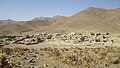 Kharpahlou Village
 -
 Painting attributed to Amir Kabir, National Museum of Iran
 -
 14th century ceramic bowl with hare and flying Simurghs from Sultanabad (today Arak)


References[edit]
- ^ a b c d "Census of the Islamic Republic of Iran, 1395 (2016)". AMAR (in Persian). The Statistical Center of Iran. p. 00. Archived from the original (Excel) on 17 October 2020. Retrieved 19 December 2022.
- ^ "Sub-national HDI - Area Database - Global Data Lab". hdi.globaldatalab.org. Retrieved 2018-09-13.
- ^ a b "Census of the Islamic Republic of Iran, 1385 (2006)". AMAR (in Persian). The Statistical Center of Iran. p. 00. Archived from the original (Excel) on 20 September 2011. Retrieved 25 September 2022.
- ^ a b "Census of the Islamic Republic of Iran, 1390 (2011)" (Excel). Iran Data Portal (in Persian). The Statistical Center of Iran. p. 00. Retrieved 19 December 2022.
- ^ a b "همشهری آنلاین-استانهای کشور به ۵ منطقه تقسیم شدند (Provinces were divided into 5 regions)". Hamshahri Online (in Persian). June 23, 2014. Archived from the original on June 23, 2014.
- ^ a b "Islamic Azad University of Khomein". Iaukhomein.ac.ir. Archived from the original on 2012-08-12. Retrieved 2012-08-07.
- ^ Islamic Azad University of Saveh (in Persian). Iau-saveh.ac.ir. Retrieved 2012-08-07.
- ^ "Islamic Azad University of Farahan". Iau-farahan.ac.ir. Retrieved 2012-08-07.
- ^ "موسسه آموزش عالي غير انتفاعي غير دولتي انرژي ساوه". Energy.ac.ir. 2012-07-25. Retrieved 2012-08-07.
External links[edit]
- Markazi Government General
- Foreign Commercial Centre of Markazi Province
- Cultural Heritage Organization of Markazi province
- Iran Chamber of Commerce, Industries & Mines
Places adjacent to Markazi province | |
|---|---|
Markazi Province, Iran | |||||||||||||||||||||||||
|---|---|---|---|---|---|---|---|---|---|---|---|---|---|---|---|---|---|---|---|---|---|---|---|---|---|
| Capital |  | ||||||||||||||||||||||||
| Counties and cities |
| ||||||||||||||||||||||||
| Sights |
| ||||||||||||||||||||||||
| populated places | |||||||||||||||||||||||||
| Authority control databases: National |
|---|