
Portal:World
The World Portal


The world is the totality of entities, the whole of reality, or everything that exists. The nature of the world has been conceptualized differently in different fields. Some conceptions see the world as unique while others talk of a "plurality of worlds". Some treat the world as one simple object while others analyze the world as a complex made up of parts.
In scientific cosmology, the world or universe is commonly defined as "[t]he totality of all space and time; all that is, has been, and will be". Theories of modality talk of possible worlds as complete and consistent ways how things could have been. Phenomenology, starting from the horizon of co-given objects present in the periphery of every experience, defines the world as the biggest horizon or the "horizon of all horizons". In philosophy of mind, the world is contrasted with the mind as that which is represented by the mind. Theology conceptualizes the world in relation to God, for example, as God's creation, as identical to God or as the two being interdependent. In religions, there is a tendency to downgrade the material or sensory world in favor of a spiritual world to be sought through religious practice. A comprehensive representation of the world and our place in it, as is found in religions, is known as a worldview. Cosmogony is the field that studies the origin or creation of the world while eschatology refers to the science or doctrine of the last things or of the end of the world.
In various contexts, the term "world" takes a more restricted meaning associated, for example, with the Earth and all life on it, with humanity as a whole or with an international or intercontinental scope. In this sense, world history refers to the history of humanity as a whole and world politics is the discipline of political science studying issues that transcend nations and continents. Other examples include terms such as "world religion", "world language", "world government", "world war", "world population", "world economy", or "world championship". (Full article...)
Selected articles -
-
 The Kyoto Protocol (Japanese: 京都議定書, Hepburn: Kyōto Giteisho) was an international treaty which extended the 1992 United Nations Framework Convention on Climate Change (UNFCCC) that commits state parties to reduce greenhouse gas emissions, based on the scientific consensus that global warming is occurring and that human-made CO2 emissions are driving it. The Kyoto Protocol was adopted in Kyoto, Japan, on 11 December 1997 and entered into force on 16 February 2005. There were 192 parties (Canada withdrew from the protocol, effective December 2012) to the Protocol in 2020.
The Kyoto Protocol implemented the objective of the UNFCCC to reduce the onset of global warming by reducing greenhouse gas concentrations in the atmosphere to "a level that would prevent dangerous anthropogenic interference with the climate system" (Article 2). The Kyoto Protocol applied to the seven greenhouse gases listed in Annex A: carbon dioxide (CO2), methane (CH4), nitrous oxide (N2O), hydrofluorocarbons (HFCs), perfluorocarbons (PFCs), sulfur hexafluoride (SF6), nitrogen trifluoride (NF3). Nitrogen trifluoride was added for the second compliance period during the Doha Round. (Full article...) -

UNESCO World Heritage plaque at Doñana National Park in Andalucía, Spain
A World Heritage Site is a landmark or area with legal protection by an international convention administered by the UNESCO. World Heritage Sites are designated by UNESCO for having cultural, historical, scientific or other forms of significance. The sites are judged to contain "cultural and natural heritage around the world considered to be of outstanding value to humanity".
To be selected, a World Heritage Site is nominated by their host country and determined by the international committee to be a unique landmark which is geographically and historically identifiable and having a special cultural or physical significance. For example, World Heritage Sites might be ancient ruins or historical structures, buildings, cities, deserts, forests, islands, lakes, monuments, mountains or wilderness areas. (Full article...) -

An oryx in the Wildlife Reserve in Al Wusta in 2012. The reserve was formerly the Arabian Oryx Sanctuary, a UNESCO World Heritage Site that was delisted in 2007.
World Heritage Sites may lose their designation when the UNESCO World Heritage Committee determines that they are not properly managed or protected. The committee can place a site it is concerned about on its list of World Heritage in Danger of losing its designation, and attempts to negotiate with the local authorities to remedy the situation. If remediation fails, the committee then revokes its designation.
A country may also request to reduce the boundaries of one of its existing sites, in effect partially or fully delisting such properties. Under the World Heritage guidelines, a country must report to the committee whenever one of its properties "inscribed on the World Heritage List has seriously deteriorated, or when the necessary corrective measures have not been taken." (Full article...) -

A world map on the Winkel tripel projection,
a low-error map projection adopted by the National Geographic Society for reference maps
A world map is a map of most or all of the surface of Earth. World maps, because of their scale, must deal with the problem of projection. Maps rendered in two dimensions by necessity distort the display of the three-dimensional surface of the Earth. While this is true of any map, these distortions reach extremes in a world map. Many techniques have been developed to present world maps that address diverse technical and aesthetic goals.
Charting a world map requires global knowledge of the Earth, its oceans, and its continents. From prehistory through the Middle Ages, creating an accurate world map would have been impossible because less than half of Earth's coastlines and only a small fraction of its continental interiors were known to any culture. With exploration that began during the European Renaissance, knowledge of the Earth's surface accumulated rapidly, such that most of the world's coastlines had been mapped, at least roughly, by the mid-1700s and the continental interiors by the twentieth century. (Full article...) -

The World Economic Forum (WEF) is an international non-governmental organization based in Cologny, Canton of Geneva, Switzerland. It was founded on 24 January 1971 by German engineer Klaus Schwab.
The foundation's stated mission is "improving the state of the world by engaging business, political, academic, and other leaders of society to shape global, regional, and industry agendas". The Forum states that the world is best managed by a self-selected coalition of multinational corporations, governments and civil society organizations (CSOs), which it expresses through initiatives like the "Great Reset" and the "Global Redesign". (Full article...) -
Post-Kyoto negotiations refers to high level talks attempting to address global warming by limiting greenhouse gas emissions. Generally part of the United Nations Framework Convention on Climate Change (UNFCCC), these talks concern the period after the first "commitment period" of the Kyoto Protocol, which expired at the end of 2012. Negotiations have been mandated by the adoption of the Bali Road Map and Decision 1/CP.13 ("The Bali Action Plan").
UNFCCC negotiations are conducted within two subsidiary bodies, the Ad Hoc Working Group on Long-term Cooperative Action under the Convention (AWG-LCA) and the Ad Hoc Working Group on Further Commitments for Annex I Parties under the Kyoto Protocol (AWG-KP) and were expected to culminate in the United Nations Climate Change Conference taking place in December 2009 in Copenhagen (COP-15); negotiations are supported by a number of external processes, including the G8 process, a number of regional meetings and the Major Economies Forum on Energy and Climate that was launched by US President Barack Obama in March 2009. High level talks were held at the meeting of the G8+5 Climate Change Dialogue in February 2007 and at a number of subsequent G8 meetings, most recently leading to the adoption of the G8 leaders declaration "Responsible Leadership for a Sustainable Future" during the G8 summit in L´Aquila, Italy, in July 2009. (Full article...) -
The International Development Association (IDA) (French: Association internationale de développement) is a development finance institution which offers concessional loans and grants to the world's poorest developing countries. The IDA is a member of the World Bank Group and is headquartered in Washington, D.C. in the United States. It was established in 1960 to complement the existing International Bank for Reconstruction and Development by lending to developing countries which suffer from the lowest gross national income, from troubled creditworthiness, or from the lowest per capita income. Together, the International Development Association and International Bank for Reconstruction and Development are collectively generally known as the World Bank, as they follow the same executive leadership and operate with the same staff.
The association shares the World Bank's mission of reducing poverty and aims to provide affordable development financing to countries whose credit risk is so prohibitive that they cannot afford to borrow commercially or from the Bank's other programs. The IDA's stated aim is to assist the poorest nations in growing more quickly, equitably, and sustainably to reduce poverty. The IDA is the single largest provider of funds to economic and human development projects in the world's poorest nations. From 2000 to 2010, it financed projects which recruited and trained 3 million teachers, immunized 310 million children, funded $792 million in loans to 120,000 small and medium enterprises, built or restored 118,000 kilometers of paved roads, built or restored 1,600 bridges, and expanded access to improved water to 113 million people and improved sanitation facilities to 5.8 million people. The IDA has issued a total US$238 billion in loans and grants since its launch in 1960. Thirty-six of the association's borrowing countries have graduated from their eligibility for its concessional lending. However, nine of these countries have relapsed and have not re-graduated. (Full article...)


General images -
-
 Geologic map of North America, color-coded by age. From most recent to oldest, age is indicated by yellow, green, blue, and red. The reds and pinks indicate rock from the Archean.
 -
 The pale orange dot, an artist's impression of the early Earth which might have appeared orange through its hazy methane rich prebiotic second atmosphere. Earth's atmosphere at this stage was somewhat comparable to today's atmosphere of Titan. (from History of Earth)
 -
 Notre-Dame de Paris, France
 -
 Machu Picchu, Inca Empire, Peru
 -

-

-
 Fall of the Berlin Wall, 1989
 -

-

-
 Tracy Caldwell Dyson, a NASA astronaut, observing Earth from the Cupola module at the International Space Station on 11 September 2010 (from Earth)
 -

-
 Last Moon landing: Apollo 17 (1972)
 -
 Persepolis, Achaemenid Empire, 6th century BCE
 -
 Earth's history with time-spans of the eons to scale (from History of Earth)
 -
 Florence, birthplace of the Italian Renaissance
 -
 "Lucy", the first Australopithecus afarensis skeleton found. Lucy was only 1.06 m (3 ft 6 in) tall.
 -
 A view of Earth with its global ocean and cloud cover, which dominate Earth's surface and hydrosphere; at Earth's polar regions, its hydrosphere forms larger areas of ice cover. (from Earth)
 -
 The replicator in virtually all known life is deoxyribonucleic acid. DNA is far more complex than the original replicator and its replication systems are highly elaborate. (from History of Earth)
 -
 Earth's land use for human agriculture (from Earth)
 -
 Cross-section through a liposome (from History of Earth)
 -
 Olmec colossal head, now at the Museo de Antropología de Xalapa
 -
 Vitruvian Man by Leonardo da Vinci epitomizes the advances in art and science seen during the Renaissance. (from History of Earth)
 -

-
 Change in average surface air temperature and drivers for that change. Human activity has caused increased temperatures, with natural forces adding some variability. (from Earth)
 -
 Taj Mahal, Mughal Empire, India
 -
 Battle during 1281 Mongol invasion of Japan
 -
 Earth's western hemisphere showing topography relative to Earth's center instead of to mean sea level, as in common topographic maps (from Earth)
 -
 Shanghai. China urbanized rapidly in the 21st century.
 -

-
 Empires of the world in 1898
 -
 The Pantheon, originally a Roman temple, now a Catholic church
 -
 Tiktaalik, a fish with limb-like fins and a predecessor of tetrapods. Reconstruction from fossils about 375 million years old. (from History of Earth)
 -
 Ming dynasty section, Great Wall of China
 -
 A reconstruction of Pannotia (550 Ma). (from History of Earth)
 -
 A map of heat flow from Earth's interior to the surface of Earth's crust, mostly along the oceanic ridges (from Earth)
 -
 Artist's conception of Devonian flora (from History of Earth)
 -

-
Pale orange dot, an artist's impression of Early Earth, featuring its tinted orange methane-rich early atmosphere (from Earth)
-
 Ajloun Castle, Jordan
 -

-
 Japanese depiction of a Portuguese carrack. European maritime innovations led to proto-globalization.
 -
 A banded iron formation from the 3.15 Ga Moodies Group, Barberton Greenstone Belt, South Africa. Red layers represent the times when oxygen was available; gray layers were formed in anoxic circumstances. (from History of Earth)
 -
 An artist's impression of ice age Earth at glacial maximum. (from History of Earth)
 -
 View of Earth from the Moon by the Lunar Reconnaissance Orbiter (from Earth)
 -

-
 Chennakesava Temple, Belur, India
 -
 First airplane, the Wright Flyer, flew on 17 December 1903.
 -
 A pillar at Göbekli Tepe
 -
 An artist's impression of the Archean, the eon after Earth's formation, featuring round stromatolites, which are early oxygen-producing forms of life from billions of years ago. After the Late Heavy Bombardment, Earth's crust had cooled, its water-rich barren surface is marked by continents and volcanoes, with the Moon still orbiting Earth half as far as it is today, appearing 2.8 times larger and producing strong tides. (from Earth)
 -
 Chloroplasts in the cells of a moss (from History of Earth)
 -
 A composite image of Earth, with its different types of surface discernible: Earth's surface dominating Ocean (blue), Africa with lush (green) to dry (brown) land and Earth's polar ice in the form of Antarctic sea ice (grey) covering the Antarctic or Southern Ocean and the Antarctic ice sheet (white) covering Antarctica. (from Earth)
 -
 A High Desert storm, sweeps across the Mojave (from Earth)
 -
 Image of the physical world, captured by the Hubble Space Telescope (from World)
 -
 A schematic view of Earth's magnetosphere with solar wind flowing from left to right (from Earth)
 -
 Graph showing range of estimated partial pressure of atmospheric oxygen through geologic time (from History of Earth)
 -
Artist's impression of Earth during the later Archean, the largely cooled planetary crust and water-rich barren surface, marked by volcanoes and continents, features already round microbialites. The Moon, still orbiting Earth much closer than today and still dominating Earth's sky, produced strong tides. (from History of Earth)
-
 Earth's axial tilt causing different angles of seasonal illumination at different orbital positions around the Sun (from Earth)
 -
 Satellite time lapse imagery of Earth's rotation showing axis tilt (from Earth)
 -
 Standing Buddha from Gandhara, 2nd century CE
 -
 Map of peopling of the world (Southern Dispersal paradigm), in thousands of years ago.
 -
 Lithified stromatolites on the shores of Lake Thetis, Western Australia. Archean stromatolites are the first direct fossil traces of life on Earth. (from History of Earth)
 -
 A 580 million year old fossil of Spriggina floundensi, an animal from the Ediacaran period. Such life forms could have been ancestors to the many new forms that originated in the Cambrian Explosion. (from History of Earth)
 -
 Great Mosque of Kairouan, Tunisia, founded 670 CE
 -
 Yggdrasil, an attempt to reconstruct the Norse world tree which connects the heavens, the world, and the underworld. (from World)
 -
 A reconstruction of human history based on fossil data. (from History of Earth)
 -
 A computer-generated image mapping the prevalence of artificial satellites and space debris around Earth in geosynchronous and low Earth orbit (from Earth)
 -
 Artist's rendition of an oxinated fully-frozen Snowball Earth with no remaining liquid surface water. (from History of Earth)
 -
 Dinosaurs were the dominant terrestrial vertebrates throughout most of the Mesozoic (from History of Earth)
 -

-

-
 Pangaea was a supercontinent that existed from about 300 to 180 Ma. The outlines of the modern continents and other landmasses are indicated on this map. (from History of Earth)
 -
 Great Pyramids of Giza, Egypt
 -
 Artist's conception of Hadean Eon Earth, when it was much hotter and inhospitable to all forms of life. (from History of Earth)
 -
 Trilobites first appeared during the Cambrian period and were among the most widespread and diverse groups of Paleozoic organisms. (from History of Earth)
 -
 Artist's impression of the enormous collision that probably formed the Moon (from History of Earth)
 -

-

-
 A composite image of artificial light emissions at night on a map of Earth (from Earth)
 -
 Obelisk of Axum, Ethiopia
 -
 Angkor Wat temple complex, Cambodia, early 12th century
 -

-
 A view of Earth with different layers of its atmosphere visible: the troposphere with its clouds casting shadows, a band of stratospheric blue sky at the horizon, and a line of green airglow of the lower thermosphere around an altitude of 100 km, at the edge of space (from Earth)
 -
 Earth's atmosphere as it appears from space, as bands of different colours at the horizon. From the bottom, afterglow illuminates the troposphere in orange with silhouettes of clouds, and the stratosphere in white and blue. Next the mesosphere (pink area) extends to the yellow line of the lowest airglow, at about one hundred kilometers at the edge of space and the lower edge of the thermosphere (invisible), continuing with green and red bands of airglow or aurorae over several hundred kilometers. (from Earth)
 -

-
 Artist's impression of a Hadean landscape with the relatively newly formed Moon still looming closely over Earth and both bodies sustaining strong volcanism. (from History of Earth)
 -
 A Benin Bronze head from Nigeria
 -
 An artist's rendering of a protoplanetary disk (from History of Earth)
 -

-
 A 2012 artistic impression of the early Solar System's protoplanetary disk from which Earth and other Solar System bodies were formed (from Earth)
 -
 World population, 10,000 BCE to 2023 CE, with projection to 2100 CE (from Human history)
 -

-

-
 An animation of the changing density of productive vegetation on land (low in brown; heavy in dark green) and phytoplankton at the ocean surface (low in purple; high in yellow) (from Earth)


.jpg)


.jpg)


.jpeg)


.svg)

.jpg)


Megacities of the world -

Moscow is the capital and largest city of Russia. The city stands on the Moskva River in Central Russia, with a population estimated at 13.0 million residents within the city limits, over 18.8 million residents in the urban area, and over 21.5 million residents in the metropolitan area. The city covers an area of 2,511 square kilometers (970 sq mi), while the urban area covers 5,891 square kilometers (2,275 sq mi), and the metropolitan area covers over 26,000 square kilometers (10,000 sq mi). Moscow is among the world's largest cities, being the most populous city entirely in Europe, the largest urban and metropolitan area in Europe, and the largest city by land area on the European continent.
First documented in 1147, Moscow grew to become a prosperous and powerful city that served as the capital of the Grand Duchy of Moscow. When the Tsardom of Russia was proclaimed, Moscow remained the political and economic center for most of its history. Under the reign of Peter the Great, the Russian capital was moved to the newly founded city of Saint Petersburg in 1712, diminishing Moscow's influence. Following the Russian Revolution and the establishment of the Russian SFSR, the capital was moved back to Moscow in 1918, where it later became the political center of the Soviet Union. In the aftermath of the dissolution of the Soviet Union, Moscow remained the capital city of the newly established Russian Federation. (Full article...)Did you know -

- ... that the Baratal limestone in Russia may be one of the oldest atolls in the world?
- ... that medieval literature scholar Theodore Silverstein's unit in World War II took over the Eiffel Tower to intercept communications of German aircraft?
- ... that the bones of Dante were to be taken to Mussolini's intended last stand against the Allies at the Valtellina Redoubt?
- ... that Pulaski's Masterpiece, billed as the "world's most valuable dog", disappeared without a trace in 1953?
- ... that the Bush Tower, near New York City's Times Square, was an attempt at a trade center before the World Trade Center itself?
- ... that ice hockey player Mitch Love once fought 34 times in one season, more than any other professional player in the world that year?
- ... that during World War I, Roy W. Ritner was elected unopposed to the Oregon State Senate while serving with the American Red Cross in France?
- ... that although the April 1923 Kamchatka earthquake had a surface-wave magnitude of 6.8 to 7.3, its tsunami was larger than that of the magnitude-8.4 earthquake in February in the same region?
Countries of the world -

Bulgaria, officially the Republic of Bulgaria, is a country in Southeast Europe. Located west of the Black Sea and south of the Danube river, Bulgaria is bordered by Greece and Turkey to the south, Serbia and North Macedonia to the west, and Romania to the north. It covers a territory of 110,994 square kilometres (42,855 sq mi) and is the 16th largest country in Europe. Sofia is the nation's capital and largest city; other major cities include Burgas, Plovdiv, and Varna.
One of the earliest societies in the lands of modern-day Bulgaria was the Neolithic Karanovo culture, which dates back to 6,500 BC. In the 6th to 3rd century BC, the region was a battleground for ancient Thracians, Persians, Celts and Macedonians; stability came when the Roman Empire conquered the region in AD 45. After the Roman state splintered, tribal invasions in the region resumed. Around the 6th century, these territories were settled by the early Slavs. The Bulgars, led by Asparuh, attacked from the lands of Old Great Bulgaria and permanently invaded the Balkans in the late 7th century. They established the First Bulgarian Empire, victoriously recognised by treaty in 681 AD by the Byzantine Empire. It dominated most of the Balkans and significantly influenced Slavic cultures by developing the Cyrillic script. The First Bulgarian Empire lasted until the early 11th century, when Byzantine emperor Basil II conquered and dismantled it. A successful Bulgarian revolt in 1185 established a Second Bulgarian Empire, which reached its apex under Ivan Asen II (1218–1241). After numerous exhausting wars and feudal strife, the empire disintegrated and in 1396 fell under Ottoman rule for nearly five centuries. (Full article...)
The New 7 Wonders of the World was a campaign started in 2001 to choose Wonders of the World from a selection of 200 existing monuments. The popularity poll via free Web-based voting and small amounts of telephone voting was led by Canadian-Swiss Bernard Weber and organized by the New 7 Wonders Foundation (N7W) based in Zurich, Switzerland, with winners announced on 7 July 2007 in Lisbon, at Estádio da Luz. The poll was considered unscientific partly because it was possible for people to cast multiple votes. According to John Zogby, founder and current President/CEO of the Utica, New York–based polling organization Zogby International, New 7 Wonders Foundation drove "the largest poll on record".
The program drew a wide range of official reactions. Some countries touted their finalist and tried to get more votes cast for it, while others downplayed or criticized the contest. After supporting the New 7 Wonders Foundation at the beginning of the campaign by providing advice on nominee selection, the United Nations Educational, Scientific, and Cultural Organization (UNESCO), bound by its bylaws to record and give equal status to all World Heritage Sites, distanced itself from the undertaking in 2001 and again in 2007. (Full article...)Related portals
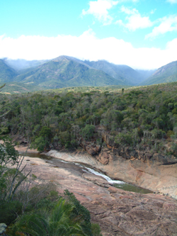
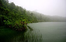
Protected areas of the world -
-
Andohahela National Park in southern Madagascar
The national parks of Madagascar include all officially recognized protected areas as of 2015. The protected areas network of Madagascar is managed by the Madagascar National Parks Association (PNM-ANGAP). The network includes three types of protected areas: Strict Nature Reserves (IUCN category Ia), National Parks (IUCN category II) and Wildlife Reserves (IUCN category IV). At the 2003 IUCN World Parks Congress in Durban, the Malagasy President, Marc Ravalomanana, announced an initiative to more than triple the area under protection from approximately 17,000 km2 (6,600 sq mi) to over 60,000 km2 (23,000 sq mi) (from 3% to 10% of Madagascar's area). This "Durban Vision", as it has been dubbed, involved broadening the definition of protected areas in the country and legislation has been passed to allow the creation of four new categories of protected area: Natural Parks (IUCN category II), Natural Monuments (IUCN category III), Protected Landscapes (IUCN category V), and Natural Resource Reserves (IUCN category VI). As well as allowing these new objectives for protected areas management, the new legislation also provided for entities other than PNM-ANGAP to manage protected areas, such as government ministries, community associations, NGOs and other civil society organizations, and the private sector. (Full article...) -
Bihar is a state in East India. It is bounded by Uttar Pradesh to the west, Nepal to the north, West Bengal to the east and Jharkhand to the south. About 7% of the state is protected forest area. (Full article...)
-

Grand Canyon of Yellowstone
The protected areas of the United States are managed by an array of different federal, state, tribal and local level authorities and receive widely varying levels of protection. Some areas are managed as wilderness, while others are operated with acceptable commercial exploitation. , the 42,826 protected areas covered 1,235,486 km2 (477,024 sq mi), or 13 percent of the land area of the United States. This is also one-tenth of the protected land area of the world. The U.S. also had a total of 871 National Marine Protected Areas, covering an additional 1,240,000 sq mi (3,200,000 km2), or 26 percent of the total marine area of the United States. (Full article...) -
-
The Protected areas of Kyrgyzstan are regulated by the law on specially protected natural areas of 2 May 2011, last modified on 2 June 2018. In total, they cover 14,761.216 km2 (5,699.337 sq mi) and account for 7.38% of the country's total area (as of 2017). The first protected area in Kyrgyzstan (Issyk-Kul) was established in 1948. According to the Government Decree on Priorities of Conservation of Biological Diversity and the relevant Action Plan for 2014-2024 the target area for the protected areas in Kyrgyzstan is 10 percent of the country’s area by 2024.
The protected areas are subdivided into seven categories: (Full article...) -
This is a list of protected areas of Saudi Arabia, some of which are managed by the Saudi Wildlife Authority.:
- At-Taysiyah Protected Area
- Jabal Shada Nature Reserve
- Majami'al-Hadb Protected Area
- Nafud al-'Urayq
- Raydah Natural Reserve
- 'Uruq Bani Ma'arid
- Saja Umm Ar-Rimth Natural Reserve
- Harrat al-Harrah Protected Area
- Al-Khunfah Natural Reserve
- Ibex Reserve Protected Area
- Mahazat as-Sayd Protected Area
- Umm al-Qamari Islands
- Al-Tubayq Natural Reserve
- Farasan Islands Protected Area
- Jubail Marine Wildlife Sanctuary
- Jabal Aja Protected Area
- Wadi Turabah Nature Reserve
-
Greece is characterized by an extremely fragmented, rugged landscape hosting a great diversity of ecosystems and an outstanding biodiversity. Almost 5% of its extensive coastline consists of ecologically sensitive wetlands. Two thirds of the total population live no further than 2 km from the coast and most of the important urban centers are coastal, while almost all of the tourist infrastructure is divided among islands and the coastal mainland. (Full article...)
-

Tijuca Forest National Park
Protected areas of Brazil included various classes of area according to the National System of Nature Conservation Units (SNUC), a formal, unified system for federal, state and municipal parks created in 2000. (Full article...) -
Papua New Guinea is home to several protected areas, which receive protection because of their environmental, cultural or similar value.
The total area of Papua New Guinea protected territories is 14,330 km2 (5,530 sq mi), which amounts to approximately 3.07% of the country's territory. The total number of protected areas as 2018 is 71. (Full article...) -
Upolu Island, Samoa
This is a list of some protected areas of Samoa which include national parks, reservations, protected nature zones, marine reserves and other areas of significant biodiversity and conservation.
In 1994, Samoa ratified the international and legally binding treaty, the Convention on Biological Diversity to develop national strategies for conservation and sustainable use of biological diversity. In 2010, protected areas in the country cover 5% of land although the government aims to increase protected areas coverage to 15%. (Full article...) -
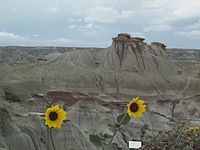
Dinosaur Provincial Park
This is a list of protected areas of Alberta. Protected areas are managed by the Government of Canada or the Government of Alberta. The provincial government owns 60% of Alberta's landmass but most of this has not been formally protected. The total protected area throughout Alberta including federal and provincial protected areas is approximately 90,700 km2 (35,000 sq mi). (Full article...) -
Cadw is the historic environment service of the Welsh Government which manages historical buildings and ancient monuments in Wales. (Full article...)
-

A view at Kintrishi National Park
The South Caucasian nation of Georgia is home to several protected areas, which receive protection because of their environmental, cultural or similar value. The oldest of these – now known as the Lagodekhi Protected Areas – dates back to 1912, when Georgia was part of the Russian Empire.
The total area of Georgia's protected terrestrial territories is 6,501 km2 (2,510 sq mi), which amounts to approximately 9.29% of the country's territory. In addition 153 km2 (59 sq mi) of marine area protected, or 0.67% of the country's territorial waters. There are a total of 89 protected areas, including 14 Strict Nature Reserves, 12 National Parks, 20 Managed Nature Reserves, 40 Natural Monuments, 2 Ramsar sites and 1 Protected Landscape. Strict nature reserves comprise 140,672 ha, while national parks cover 276,724 ha. The total number of visitors to Georgia's protected areas was just under 1.2 million in 2019. (Full article...) -
The protected areas of Michigan come in an array of different types and levels of protection. Michigan has five units of the National Park Service system. There are 14 federal wilderness areas; the majority of these are also tribal-designated wildernesses. It has one of the largest state forest systems as well having four national forests. The state maintains a large state park system and there are also regional parks, and county, township and city parks. Still other parks on land and in the Great Lakes are maintained by other governmental bodies. Private protected areas also exist in the state, mainly lands owned by land conservancies. (Full article...)
-
Protected areas of Slovenia include one national park (Slovene: narodni park), three regional parks (regijski park), several natural parks (krajinski park), and hundreds of natural monuments (naravni spomenik) and monuments of designed nature (spomenik oblikovane narave). They cover about 12.5% of the Slovenian territory. Under the Wild Birds Directive, 26 sites totalling roughly 25% of the nation's land are "Special Protected Areas"; the Natura 2000 proposal would increase the totals to 260 sites and 32% of national territory. (Full article...)


Selected world maps
-
 Only a few of the largest large igneous provinces appear (coloured dark purple) on this geological map, which depicts crustal geologic provinces as seen in seismic refraction data
 -
 The world map by Gerardus Mercator (1569), the first map in the well-known Mercator projection
 -
 1516 map of the world by Martin Waldseemüller
 -
 United Nations Human Development Index map by country (2016)
 -
 Mollweide projection of the world
 -
 Index map from the International Map of the World (1:1,000,000 scale)
 -
 Time zones of the world
 -
 A plate tectonics map with volcano locations indicated with red circles
 -
 The Goode homolosine projection is a pseudocylindrical, equal-area, composite map projection used for world maps.


World records
- List of Olympic records in athletics
- List of world records in athletics
- List of junior world records in athletics
- List of world records in masters athletics
- List of world youth bests in athletics
- List of IPC world records in athletics
- List of world records in canoeing
- List of world records in chess
- List of cycling records
- List of world records in track cycling
- List of world records in finswimming
- List of world records in juggling
- List of world records in rowing
- List of world records in speed skating
- List of world records in swimming
- List of IPC world records in swimming
- List of world records in Olympic weightlifting
Topics

Continents of Earth | ||||||||
|---|---|---|---|---|---|---|---|---|
| ||||||||
| ||||||||
| ||||||||


| Cenozoic Era (present–66.0 Ma) |
| ||||||||||||
|---|---|---|---|---|---|---|---|---|---|---|---|---|---|
| Mesozoic Era (66.0–252 Ma) |
| ||||||||||||
| Paleozoic Era (252–539 Ma) |
| ||||||||||||
| Proterozoic Eon (539 Ma–2.5 Ga) |
| ||||||||||||
| Archean Eon (2.5–4 Ga) | |||||||||||||
| Hadean Eon (4–4.6 Ga) | |||||||||||||
ka = kiloannum (thousands years ago); Ma = megaannum (millions years ago); Ga = gigaannum (billions years ago). See also: Geologic time scale • | |||||||||||||
| Locations | ||
|---|---|---|
| Related | ||

| |||||||||||||||||||
| |||||||||||||||||||
| |||||||||||||||||||

Economic classification of countries | |||||
|---|---|---|---|---|---|
| Three-World Model | |||||
| Gross domestic product (GDP) |
| ||||
| Gross national income (GNI) | |||||
| Wages | |||||
| Wealth | |||||
| Other national accounts | |||||
| Human development | |||||
| Digital divide | |||||
| Net international investment position (NIIP) | |||||
| Technological |
| ||||
|---|---|---|---|---|---|
| Sociological | |||||
| Ecological |
| ||||
| Biological |
| ||||
| Astronomical | |||||
| Eschatological |
| ||||
| Others |
| ||||
| Fictional | |||||
| Organizations | |||||
Categories

Wikimedia
The following Wikimedia Foundation sister projects provide more on this subject:
-
 Commons
Free media repository -
 Wikibooks
Free textbooks and manuals -
 Wikidata
Free knowledge base -
 Wikinews
Free-content news -
 Wikiquote
Collection of quotations -
 Wikisource
Free-content library -
 Wikispecies
Directory of species -
 Wikiversity
Free learning tools -
 Wikivoyage
Free travel guide -
 Wiktionary
Dictionary and thesaurus


