
Sannō Shrine
| Sannō Shrine (山王神社) | |
|---|---|
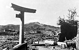
 The one-legged torii at the Sannō Shrine | |
| Religion | |
| Affiliation | Shinto |
| Location | |
 Shown within Japan | |
| Geographic coordinates | 32°46′03″N 129°52′07″E / 32.76750°N 129.86861°E |
The Sannō Shrine (山王神社, Sannō Jinja, literally Mountain king shrine), located about 800 metres south-east of the atomic bomb hypocentre in Nagasaki, is noted for its one-legged stone torii at the shrine entrance.
Torii[edit]
The well-known one-legged torii or one-legged arch (一本柱鳥居) was one of the unanticipated results of the atomic bomb blast on August 9, 1945.
The epicenter of the bomb's destructive force was located approximately 800 meters from the shrine (in the right background of the image on the left).
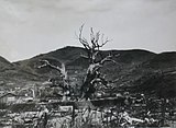
One support column was knocked down; but the other somehow remained standing, keeping the gate upright but effectively breaking it in half. The force of the shockwave rotated the torii about 30 degrees on its pedestal base. The central part of the shrine is located just behind the photographer of the image on the right.[1]
Trees[edit]
The surviving trees of Sannō Shrine have become another living demonstration of destruction and re-growth. Two large camphor trees were scorched, burned and stripped of all leaves by the bomb's shock wave; and yet, despite everything, the trees survived. One tree in Nagasaki was designated a natural monument on February 15, 1969.[2]
The dead parts of the living trees have been enveloped by new growth. [1]
Gallery[edit]
-
 The one-legged torii of Sannō Shrine is circled in red.
 -
 Camphor Tree Sannō Shinto Shrine Nagasaki, 2014
 -
 The one-legged torii and rubble after the atomic blast, 1945
 -
 The devastated Sannō camphor trees, 1945
 -
 View of entrance to the Shrine in 2014
 -
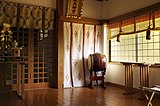 View of the Shrine interior in 2014


Notes[edit]
- ^ a b City of Nagasaki Archived 2009-08-15 at the Wayback Machine: Nagasaki Atomic Bomb Museum Archived 2012-01-22 at the Wayback Machine; Sannō Shrine Archived 2011-02-10 at the Wayback Machine.
- ^ Brazil, Mark. "A camphor by any other name," The Japan Times. August 1, 2002.
This article relating to Shinto is a stub. You can help Wikipedia by expanding it. |
| Gods |
|  | |||||
|---|---|---|---|---|---|---|---|
| Places |
| ||||||
- Monuments and memorials in Japan
- Shinto shrines in Nagasaki Prefecture
- Religious buildings and structures in Nagasaki
- Monuments and memorials concerning the atomic bombings of Hiroshima and Nagasaki
- Chinjusha
- Religious buildings and structures completed in 1638
- Religious buildings and structures completed in 1869
- Independent shrines
- Shinmei shrines
- Sannō Ichijitsu Shintō
- Shinto stubs