VII Dwór
VII Dwór | |
|---|---|
District of Gdańsk | |
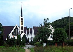
 Saint Stanislaus Kostka church with the Oliwa forests in the background | |
 Location of VII Dwór within Gdańsk | |
| Coordinates: 54°23′12″N 18°34′33″E / 54.386714°N 18.575826°E | |
| Country | |
| Voivodeship | Pomeranian |
| County/City | Gdańsk |
| Within city limits | 1926 |
| Area | |
| • Total | 2.90 km2 (1.12 sq mi) |
| Population (2021[1]) | |
| • Total | 3,560 |
| • Density | 1,200/km2 (3,200/sq mi) |
| Time zone | UTC+1 (CET) |
| • Summer (DST) | UTC+2 (CEST) |
| Vehicle registration | GD |
VII Dwór, read as Siódmy Dwór [ˈɕudmɨ ˈdvur] (meaning "Seventh Manor House"), is an administrative district (dzielnica) in the city of Gdańsk, Poland.
It borders Oliwa in the north and west, Strzyża in the east, Brętowo in the south and Wrzeszcz Górny in the south-east.
The 7th Polish Navy Hospital is located in VII Dwór.
During the German occupation in World War II, the occupiers operated a subcamp of the Stalag XX-B prisoner-of-war camp for Allied POWs in the present-day district of VII Dwór.[2]
References[edit]
- ^ a b "Podział administracyjny Gdańska". BIP - Urząd Miejski w Gdańsku (in Polish). Retrieved 12 March 2023.
- ^ Daniluk, Jan. "Stalag XX B Marienburg: geneza i znaczenie obozu jenieckiego w Malborku-Wielbarku w latach II wojny światowej". In Grudziecka, Beata (ed.). Stalag XX B: historia nieopowiedziana (in Polish). Malbork: Muzeum Miasta Malborka. p. 9. ISBN 978-83-950992-2-9.
