
Portal:Myanmar
ကြိုဆိုပါတယ်။ / Welcome to the Myanmar Portal 

Myanmar, officially the Republic of the Union of Myanmar and also known as Burma (the official name until 1989), is a country in Southeast Asia. It is the largest country by area in Mainland Southeast Asia and has a population of about 55 million. It is bordered by Bangladesh and India to its northwest, China to its northeast, Laos and Thailand to its east and southeast, and the Andaman Sea and the Bay of Bengal to its south and southwest. The country's capital city is Naypyidaw, and its largest city is Yangon (formerly Rangoon).
Myanmar is a member of the East Asia Summit, Non-Aligned Movement, ASEAN, and BIMSTEC, but it is not a member of the Commonwealth of Nations despite once being part of the British Empire. Myanmar is a Dialogue Partner of the Shanghai Cooperation Organization. The country is very rich in natural resources, such as jade, gems, oil, natural gas, teak and other minerals, as well as also endowed with renewable energy, having the highest solar power potential compared to other countries of the Great Mekong Subregion. However, Myanmar has long suffered from instability, factional violence, corruption, poor infrastructure, as well as a long history of colonial exploitation with little regard to human development. In 2013, its GDP (nominal) stood at US$56.7 billion and its GDP (PPP) at US$221.5 billion. The income gap in Myanmar is among the widest in the world, as a large proportion of the economy is controlled by cronies of the military junta. Myanmar is one of the least developed countries; as of 2020, according to the Human Development Index, it ranks 147 out of 189 countries in terms of human development, the lowest in Southeast Asia. Since 2021, more than 600,000 people were displaced across Myanmar due to the surge in violence post-coup, with more than 3 million people in dire need of humanitarian assistance. (Full article...)
Selected articles -
-
 The COVID-19 pandemic in Myanmar is part of the worldwide pandemic of coronavirus disease 2019 (COVID-19) caused by severe acute respiratory syndrome coronavirus 2 (SARS-CoV-2). The virus was confirmed to have reached Myanmar on 23 March 2020. On 31 March 2020, the Committee for Coronavirus Disease 19 (COVID-19), headed by First Vice President Myint Swe and made up of members from the various union ministries, was formed by President Win Myint to combat the spread of COVID-19 in the country.
Although the government rapidly implemented containment measures and public health responses, the country had experienced one of the most severe COVID-19 outbreaks in Southeast Asia by late 2020. The UN raised concerns about Myanmar's vulnerability to the pandemic due to its weak healthcare infrastructure following poor investment over six decades of military rule, as well as ongoing internal conflict. (Full article...) -
The prehistory of Burma (Myanmar) spanned hundreds of millennia to about 200 BCE. Archaeological evidence shows that the Homo erectus had lived in the region now known as Burma as early as 750,000 years ago, and the Homo sapiens about 11,000 BCE, in a Stone Age culture called the Anyathian. Named after the central dry zone sites where most of the early settlement finds are located, the Anyathian period was when plants and animals were first domesticated and polished stone tools appeared in Burma. Though these sites are situated in fertile areas, evidence shows these early people were not yet familiar with agricultural methods.
The Bronze Age arrived c. 1500 BCE when people in the region were turning copper into bronze, growing rice, and domesticating chickens and pigs. The Iron Age arrived around 500 BCE when iron-working settlements emerged in an area south of present-day Mandalay. Evidence also shows rice growing settlements of large villages and small cities that traded with their surroundings and as far as China between 500 BCE and 200 CE. Bronze-decorated coffins and burial sites filled with the earthenware remains of feasting and drinking provide a glimpse of the lifestyle of their affluent society. (Full article...) -
Atula Thiri Maha Yaza Dewi (Burmese: အတုလသီရိ မဟာရာဇ ဒေဝီ [ʔətṵla̰ θìɹḭ məhà jàza̰ dèwì]; Pali: Atulasīrimahārājadevī; c. 1518–1568) was the chief queen consort of King Bayinnaung of Burma (Myanmar) from 1550 to 1568. The queen was of Toungoo royalty, daughter of King Mingyi Nyo and younger half-sister of King Tabinshwehti. She was the mother of King Nanda. Her 1534 marriage to Bayinnaung, a commoner, solidified an unfailing alliance between Tabinshwehti and Bayinnaung who together would go on to found the Toungoo Empire (or the Second Burmese Empire). (Full article...)
-
The Irrawaddy River (Burmese: ဧရာဝတီမြစ်, pronounced [ʔèjàwədì mjɪʔ], official romanisation: Ayeyarwady) is the largest river in Myanmar. Originating from the confluence of the N'mai and Mali rivers, it flows from north to south before emptying through the Irrawaddy Delta in the Ayeyarwady Region into the Andaman Sea. Its drainage basin of about 404,000 square kilometres (156,000 sq mi) covers 61% of the land area of Burma, and contains five of its largest cities.
As early as the sixth century, the river was used for trade and transport, and an extensive network of irrigation canals was developed to support agriculture. The river is still of great importance as the largest commercial waterway of Myanmar. It also provides important ecosystem services to different communities and economic sectors, including agriculture, fisheries, and tourism. (Full article...) -
Dein Mani-Yut (Mon: ဒိန်ၝိတ်ရတ်; Burmese: ဒိန်မဏိရွတ်, Burmese pronunciation: [dèiɴ mənḭ jʊ̯ʔ]), commonly known as Amat Dein (အမတ်ဒိန်, "Minister Dein") or as Amat Tein (အမတ်တိန်, "Minister Tein"), was co-chief minister of Hanthawaddy during the reign of King Razadarit (1384–1421). He was also a senior general, and held key governorship posts at Syriam (1370s–1408), Bassein (1408–1415) and Sittaung (1415–1420s). Along with his colleague Byat Za, Dein was instrumental in Razadarit's reunification campaigns of the Mon-speaking kingdom in the late 1380s, as well as the Forty Years' War against the Burmese-speaking Ava Kingdom. (Full article...)
-

Black and white photograph of logging in Myanmar taken by a Bombay Burmah Trading Corporation official during British rule.
According to a report by the Food and Agriculture Organization of the United Nations, Myanmar (also known as Burma) lost 19%, or 7,445,000 hectares (28,750 sq mi), of forest between 1990 and 2010. With forest covering as much as 70% of Burma at the time of independence, there were only slightly more than 48% forest cover left as of 2014. The deforestation rate of Myanmar has declined from 0.95% per year in the years 1990–2010 to about 0.3% per year and deforestation in Myanmar is now less than other countries of the region such as Indonesia or Vietnam, but still remains an important environmental issue. Three main factors contribute to continued deforestation: unsustainable and illegal logging, unresolved land rights and land disputes and extensive agricultural development.
Myanmar possesses the largest expanse of tropical forest in mainland Southeast Asia with a biodiversity much greater than temperate forests. As of 2010, Burma's living forest biomass holds 1,654 million metric tons of carbon and is home to over 80 endemic species. Despite the diversity and size of Burma's forests, only 6.3% of the land is protected and much of it is under the threat of deforestation. (Full article...) -
Insurgencies have been ongoing in Myanmar since 1948, the year the country, then known as Burma, gained independence from the United Kingdom. The conflict has largely been ethnic-based, with several ethnic armed groups fighting Myanmar's armed forces, the Tatmadaw, for self-determination. Despite numerous ceasefires and the creation of autonomous self-administered zones in 2008, many armed groups continue to call for independence, increased autonomy, or the federalisation of the country. The conflict is the world's longest ongoing civil war, having spanned more than seven decades. (Full article...) -

The 1912 Maymyo earthquake or Burma earthquake struck Burma on the morning of May 23, with an epicentre near Taunggyi and Pyin Oo Lwin in Shan State. The earthquake was initially calculated at 8.0 on the surface wave magnitude scale (Ms ) by Beno Gutenberg and Charles Francis Richter, and described by them as being one of the most remarkable seismic events in the early 1900s. Recent re-evaluation of the earthquake, however, have revised the magnitude to 7.6–7.9. It was preceded by two foreshocks on May 18 and 21 with respective intensities V and VII on the Rossi–Forel scale, while the mainshock was assigned IX. Shaking was felt throughout most of Burma, parts of Siam and Yunnan; an area covering approximately 375,000 square miles. It was one of the largest earthquakes in the country. (Full article...) -
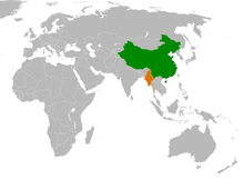
China–Myanmar relations (Chinese: 中缅关系; Burmese: တရုတ်မြန်မာဆက်ဆံရေး) are the international relations between the People's Republic of China and Myanmar. China and Myanmar have active bilateral relations with each other. The relation is often described as a pauk-phaw relationship (Burmese: ပေါက်ဖော်), based a Burmese term for kinsfolk that implicates special asymmetric obligations between the two countries.
Generally, China has maintained positive relationships with both military and elected governments in Myanmar. Bilateral relations between China and Myanmar have also faced difficulties due to alleged Chinese backing of rebels in Myanmar's territories. In recent years, the relations between China and Myanmar have faced some problems due to ongoing clashes between ethnic Chinese rebels and the Myanmar military near the China–Myanmar border. (Full article...) -
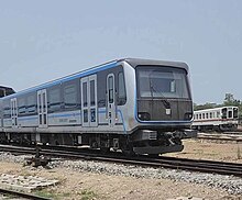
Yangon Circular Railway (Burmese: ရန်ကုန် မြို့ပတ် ရထား [jàɰ̃ɡòʊɰ̃ mjo̰baʔ jətʰá]) is the local commuter rail network that serves the Yangon metropolitan area. Operated by Myanma Railways, the 45.9-kilometre (28.5 mi) 39-station loop system connects satellite towns and suburban areas to the city. Circa 2008–2010, the railway had about 200 coaches, had 20 daily runs, and sold 100,000 to 150,000 tickets daily.
The railway is heavily utilized by lower-income commuters, as it is (along with buses) the cheapest method of transportation in Yangon.
The hours of service have been consistent over the years, from 3:45 am to 10:15 pm daily. In 2011, the cost of a ticket for a distance of 15 miles was two hundred kyats (~eighteen US cents), and that for over 15 miles was four hundred kyats (~37 US cents). In the new currency (introduced in 2012) long distance tickets are 200 kyat (~20 US cents). (Full article...)


Did you know (auto-generated) -

- ... that the talabaw soup, which consists primarily of bamboo shoots, is the essential dish of Myanmar's Karen people, who use it to supplement rice?
- ... that Rolling Stone named Mission of Burma's "Academy Fight Song" as one of the 100 greatest debut singles of all time?
- ... that the Myanmar Photo Archive (example photograph shown) revealed "a side of modern Myanmar that, until very recently, remained hidden in dusty attics"?
- ... that one academic described the introduction of femboys to Myanmar as a tactic to achieve an "ideological revolution"?
- ... that Esther Ze Naw, who appeared on the 2021 Time 100, was one of the few people in Myanmar who protested against Aung San Suu Kyi's defence of the military at the International Court of Justice in December 2019?
- ... that as part of the coronation of Mindon Min, the square yuzana around the capital was designated a sanctuary?
- ... that Maw Htun Aung, a Shan Nationalities League for Democracy candidate in the 2020 Myanmar general election, is Kachin, not Shan?
- ... that squatters in Myanmar were punished for protesting against the 2021 coup d'état by being evicted?
Related portals and projects
General images -
-
 Aung San Suu Kyi addresses crowds at the NLD headquarters shortly after her release. (from History of Myanmar)
 -
 A theatrical performance of the Mon dance (from Culture of Myanmar)
 -

-
 The shores of Irrawaddy River at Nyaung-U, Bagan (from Geography of Myanmar)
 -
 Vegetable stall on the roadside at the Madras Lancer Lines, Mandalay, January 1886. Photographer: Hooper, Willoughby Wallace (1837–1912). (from History of Myanmar)
 -
 Protesters in Yangon with a banner that reads non-violence: national movement in Burmese, in the background is Shwedagon Pagoda. (from History of Myanmar)
 -
 A bull fight, 19th-century watercolour (from Culture of Myanmar)
 -
 19th-century funeral cart and spire, which would form part of the procession from the home to the place of cremation (from Culture of Myanmar)
 -
 Former US President Barack Obama poses barefoot on the grounds of Shwedagon Pagoda, one of Myanmar's major Buddhist pilgrimage sites. (from Culture of Myanmar)
 -
 Two female musicians play the saung at a performance in Mandalay. (from Culture of Myanmar)
 -
 A wedding procession, with the groom and bride dressed in traditional Burmese wedding clothes, reminiscent of royal attire (from Culture of Myanmar)
 -
 Boxing match, 19th-century watercolour (from Culture of Myanmar)
 -
 Pagan Kingdom during Narapatisithu's reign. Burmese chronicles also claim Kengtung and Chiang Mai. Core areas shown in darker yellow. Peripheral areas in light yellow. Pagan incorporated key ports of Lower Burma into its core administration by the 13th century. (from History of Myanmar)
 -
 Portuguese ruler and soldiers mounting an Elephant. Philips, Jan Caspar (draughtsman and engraver) (from History of Myanmar)
 -

-
 The restored Taungoo or Nyaungyan dynasty c. 1650 CE. (from History of Myanmar)
 -
 A wide range of Burmese lacquerware from Bagan (from Culture of Myanmar)
 -
 Temples at Mrauk U, was the capital of the Mrauk U Kingdom, which ruled over what is now Rakhine State. (from History of Myanmar)
 -
 Hlei pyaingbwè - a Burmese regatta (from Culture of Myanmar)
 -
 British soldiers dismantling cannons belonging to King Thibaw's forces, Third Anglo-Burmese War, Ava, 27 November 1885. Photographer: Hooper, Willoughby Wallace (1837–1912). (from History of Myanmar)
 -
 Grandfather Island, Dawei (from Geography of Myanmar)
 -
 The paddle steamer Ramapoora (right) of the British India Steam Navigation Company on the Rangoon river having just arrived from Moulmein. 1895. Photographers: Watts and Skeen (from History of Myanmar)
 -
 Saint Mary's Cathedral in Downtown Yangon is the largest Roman Catholic cathedral in Burma. (from Culture of Myanmar)
 -

-
 Mountains near Pindaya on the Shan Plateau (from Geography of Myanmar)
 -
 Mount Popa, a dormant volcano in the Central Lowlands (from Geography of Myanmar)
 -
 Jade Mine in Hpakant (from Geography of Myanmar)
 -
 Political Map of Burma (Myanmar) c. 1450 CE. (from History of Myanmar)
 -
 Myanmar (Burma) map of Köppen climate classification (from Geography of Myanmar)
 -
 A group of Buddhist worshipers at Shwedagon Pagoda, an important religious site for Burmese Buddhists (from Culture of Myanmar)
 -
 A large fracture on the Mingun Pahtodawgyi caused by the 1839 Ava earthquake. (from Geography of Myanmar)
 -
 Aerial view of a burned Rohingya village in Rakhine state, Myanmar, September 2017 (from History of Myanmar)
 -
 Protesters in Yangon carrying signs reading "Free Daw Aung San Suu Kyi" on 8 February 2021. (from History of Myanmar)
 -
 Sculpture of Myanmar mythical lion (from Culture of Myanmar)
 -
 Salween river at Mae Sam Laep on the Thai-Myanmar border (from Geography of Myanmar)
 -
 British soldiers on patrol in the ruins of the Burmese town of Bahe during the advance on Mandalay, January 1945. (from History of Myanmar)
 -
 British soldiers remove their shoes at the entrance of Shwedagon Pagoda. To the left, a sign reads "Foot wearing is strictly prohibited" in Burmese, English, Tamil, and Urdu. (from Culture of Myanmar)
 -
 Myinhkin thabin - equestrian sport (from Culture of Myanmar)
 -

-
 Recorder's Court on Sule Pagoda Road, with the Sule Pagoda at the far end, Rangoon, 1868. Photographer: J. Jackson. (from History of Myanmar)
_headquarter.jpg)


Major topics
Categories

More topics

Associated Wikimedia
The following Wikimedia Foundation sister projects provide more on this subject:
-
 Commons
Free media repository -
 Wikibooks
Free textbooks and manuals -
 Wikidata
Free knowledge base -
 Wikinews
Free-content news -
 Wikiquote
Collection of quotations -
 Wikisource
Free-content library -
 Wikiversity
Free learning tools -
 Wikivoyage
Free travel guide -
 Wiktionary
Dictionary and thesaurus


